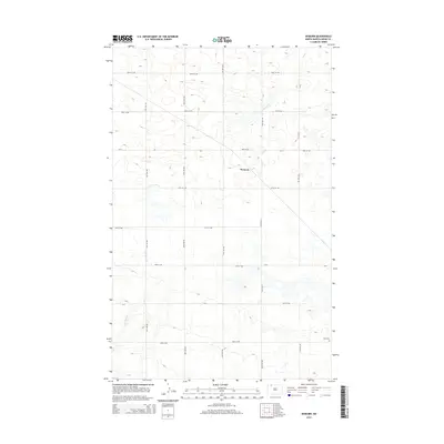
2014 Map of Woburn
USGS Topo · Published 2014About this map
Woburn stands at the intersection of several county roads in the northern reaches of Burke County, surrounded by a high-plains landscape defined by seasonal drainages and glacial depressions. The local geography is marked by the winding courses of Stony Cr in the northeast and E Br Short Cr to the southwest, which carve subtle paths through the prairie. While the settlement itself remains the central point of reference, the surrounding rural landscape is anchored by the Zion Cem in the southeast corner. This 2014 survey illustrates the persistent section-line road network, including routes like CR-4 and CR-13, which has dictated the pattern of agriculture and transport in this part of North Dakota for generations.
Find a feature on this map
20 named features on this map. Tap any name to fly to it.
Don’t see what you’re looking for? This feature index may not catch every label — zoom into the map to look around manually.
Map Details
Editions of this 2014 Woburn Map
This is the sole edition of this map. No revisions or reprints were ever made.
Other maps of this area

1947 · Flaxton
USGS Topo · 1:24,000

1948 · Flaxton
USGS Topo · 1:24,000

1948 · Coteau
USGS Topo · 1:24,000

1948 · Woburn
USGS Topo · 1:24,000

1948 · Vanville NE
USGS Topo · 1:24,000

1949 · Rennie Lake
USGS Topo · 1:24,000

1949 · Portal
USGS Topo · 1:24,000
1949 · Northgate
USGS Topo · 1:24,000

1950 · Vanville NE
USGS Topo · 1:24,000

1950 · Flaxton
USGS Topo · 1:62,500