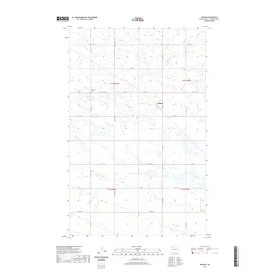
2020 Map of Woburn
USGS Topo · Published 2020About this map
Woburn sits amidst the characteristic prairie pothole terrain of Burke County, where a dense network of small wetlands and depressions defines the rural landscape. This modern survey illustrates the persistent agricultural grid of the northern plains, marked by section lines and gravel routes like Co Rd 4 and Co Rd 8. Family history and early community ties are anchored by local landmarks such as the Dale Lutheran Cem in the northwest and Zion Cem in the southeast corner. Small drainage patterns, including Stony Creek and the E Br Short Cr, provide the primary relief in an otherwise subtle topography. The map documents the enduring layout of township and range lines, such as t162n r91w, which have governed land division in this region since settlement.
Find a feature on this map
20 named features on this map. Tap any name to fly to it.
Don’t see what you’re looking for? This feature index may not catch every label — zoom into the map to look around manually.
Map Details
Editions of this 2020 Woburn Map
This is the sole edition of this map. No revisions or reprints were ever made.
Other maps of this area

1947 · Flaxton
USGS Topo · 1:24,000

1948 · Flaxton
USGS Topo · 1:24,000

1948 · Coteau
USGS Topo · 1:24,000

1948 · Woburn
USGS Topo · 1:24,000

1948 · Vanville NE
USGS Topo · 1:24,000

1949 · Rennie Lake
USGS Topo · 1:24,000

1949 · Portal
USGS Topo · 1:24,000
1949 · Northgate
USGS Topo · 1:24,000

1950 · Vanville NE
USGS Topo · 1:24,000

1950 · Flaxton
USGS Topo · 1:62,500