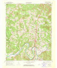
1969 Map of Wofford
USGS Topo · Published 1972About this map
The Cumberland River carves deep, dramatic oxbows through this portion of Whitley County, creating distinctive landforms like Crorey Bend and Prewitt Bend. This 1969 revision captures the intersection of traditional Appalachian settlement patterns with modern mid-century infrastructure, such as the Williamsburg Cumberland Falls Airport and the sprawling Whitley County High Sch campus near Goldbug. The Louisville and Nashville railroad tracks follow the river's winding course, serving smaller communities like Wofford and Browns as they head toward Williamsburg.
Find a feature on this map
42 named features on this map. Tap any name to fly to it.
Don’t see what you’re looking for? This feature index may not catch every label — zoom into the map to look around manually.
Map Details
Editions of this 1969 Wofford Map
3 editions found
Other maps of this area

1890 · Williamsburg
USGS Topo · 1:125,000

1894 · Williamsburg
USGS Topo · 1:125,000

1952 · Corbin
USGS Topo · 1:24,000

1952 · Wofford
USGS Topo · 1:24,000

1952 · Vox
USGS Topo · 1:24,000

1952 · Saxton
USGS Topo · 1:24,000

1952 · Hollyhill
USGS Topo · 1:24,000

1952 · Rockholds
USGS Topo · 1:24,000

1952 · Cumberland Falls
USGS Topo · 1:24,000

1952 · Williamsburg
USGS Topo · 1:24,000