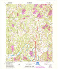
1969 Map of Wofford
USGS Topo · Published 1983About this map
The Cumberland River carves deep, dramatic loops at Croley Bend and Prewitt Bend as it winds through Whitley County. This landscape is defined by the convergence of heavy transport and natural resource extraction during the late twentieth century, with Seaboard rail lines and the prominent Interchange 15 facilitating movement between the riverside settlements and the higher ridges. The southern portion of the sheet reveals the suburban and institutional growth of Williamsburg, including the County High Sch and Highland Park, while the rugged north remains largely within the Daniel Boone National Forest. Local history is anchored by rural landmarks such as Youngs Creek Ch and Piney Grove Ch, alongside evidence of the region's energy economy shown through various Oil Wells and a Strip Mine.
Find a feature on this map
40 named features on this map. Tap any name to fly to it.
Don’t see what you’re looking for? This feature index may not catch every label — zoom into the map to look around manually.
Map Details
Editions of this 1969 Wofford Map
3 editions found
Other maps of this area

1890 · Williamsburg
USGS Topo · 1:125,000

1894 · Williamsburg
USGS Topo · 1:125,000

1952 · Corbin
USGS Topo · 1:24,000

1952 · Wofford
USGS Topo · 1:24,000

1952 · Vox
USGS Topo · 1:24,000

1952 · Saxton
USGS Topo · 1:24,000

1952 · Hollyhill
USGS Topo · 1:24,000

1952 · Rockholds
USGS Topo · 1:24,000

1952 · Cumberland Falls
USGS Topo · 1:24,000

1952 · Williamsburg
USGS Topo · 1:24,000