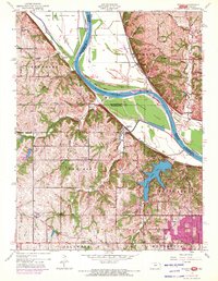
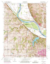
1948 Map of Wolcott
USGS Topo · Published 1971About this map
The Missouri River carves a dramatic path through this 1948 survey, defining the border between Kansas and Missouri with major bends at Delaware Bend and Pope Bend. Large river features like Stigers Island and Diamond Island dominate the waterway, while the State Penitentiary Farm occupies a significant tract on the northern floodplains. To the south, the terrain rises into the rolling hills of Wyandotte County, where Wyandotte County Lake serves as a central landmark for the surrounding community.
Find a feature on this map
55 named features on this map. Tap any name to fly to it.
Don’t see what you’re looking for? This feature index may not catch every label — zoom into the map to look around manually.
Map Details
Editions of this 1948 Wolcott Map
5 editions found
Other maps of this area

1890 · Kansas City
USGS Topo · 1:125,000

1894 · Kansas City
USGS Topo · 1:125,000

1910 · Leavenworth
USGS Topo · 1:62,500

1914 · Smithville
USGS Topo · 1:62,500

1934 · Bonner Springs
USGS Topo · 1:48,000

1934 · Shawnee
USGS Topo · 1:24,000

1934 · Edwardsville
USGS Topo · 1:24,000

1934 · Wolcott
USGS Topo · 1:24,000

1940 · Bonner Springs
USGS Topo · 1:62,500
1943 · Shawnee
USGS Topo · 1:31,680