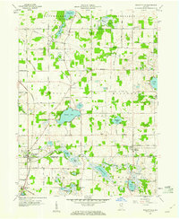
1959 Map of Wolcottville
USGS Topo · Published 1960About this map
The glacial lakes of LaGrange and Noble Counties define this mid-century landscape, centered on the intersection of the Pennsylvania and Wabash railroad lines. Wolcottville sits at the heart of this rail junction, serving as a hub for the surrounding agricultural townships of Bloomfield, Johnson, and Orange. The area is notably rich in small water bodies, including Adams Lake, Pretty Lake, and the cluster near Cree Lake and Newman Lake.
Find a feature on this map
56 named features on this map. Tap any name to fly to it.
Don’t see what you’re looking for? This feature index may not catch every label — zoom into the map to look around manually.
Map Details
Editions of this 1959 Wolcottville Map
3 editions found

Other maps of this area

1940 · Orland
USGS Topo · 1:24,000

1941 · Orland
USGS Topo · 1:24,000

1942 · Stroh
USGS Topo · 1:24,000

1947 · Mongo
USGS Topo · 1:24,000

1947 · Lagrange
USGS Topo · 1:24,000

1947 · Wolcottville
USGS Topo · 1:24,000

1947 · Oliver Lake
USGS Topo · 1:24,000

1953 · Fort Wayne
USGS Topo · 1:250,000

1955 · Corunna
USGS Topo · 1:24,000

1955 · Kendallville
USGS Topo · 1:24,000