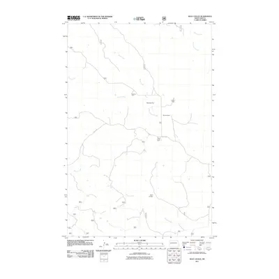
2011 Map of Wolf Coulee
USGS Topo · Published 2011About this map
Wolf Coulee and the surrounding drainage basins of western North Dakota define this landscape, where the Missouri Plateau breaks into a network of seasonal watercourses and upland flats. The area is characterized by large-scale ranching operations, with family-named landmarks such as Robinson Ranch, Schaper Ranch, and the McNaney Ranch situated among the draws. The geography is dictated by the flow of Beicegel Creek and Sheep Creek, which carve through the terrain toward larger tributaries. Significant topographical features like Maverick Flat provide a glimpse into the distribution of grazing land and the isolation of the high plains before further modern development. Local transit is largely confined to unimproved roads and Co Rte 50, highlighting the sparse, agrarian nature of this portion of McKenzie County.
Find a feature on this map
28 named features on this map. Tap any name to fly to it.
Don’t see what you’re looking for? This feature index may not catch every label — zoom into the map to look around manually.
Map Details
Editions of this 2011 Wolf Coulee Map
This is the sole edition of this map. No revisions or reprints were ever made.
Other maps of this area

1953 · Watford City
USGS Topo · 1:250,000

1957 · Watford City
USGS Topo · 1:250,000

1958 · Long X Divide
USGS Topo · 1:24,000

1958 · Sperati Point
USGS Topo · 1:24,000

1967 · Watford City
USGS Topo · 1:250,000

1970 · Hanks Gully
USGS Topo · 1:24,000

1974 · Wolf Coulee
USGS Topo · 1:24,000

1974 · Squaretop Butte
USGS Topo · 1:24,000

1974 · Buckskin Butte
USGS Topo · 1:24,000
1974 · Scairt Woman Draw
USGS Topo · 1:24,000