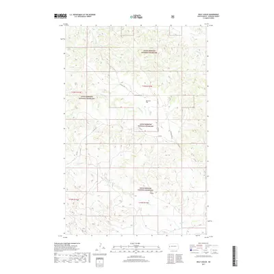
2017 Map of Wolf Coulee
USGS Topo · Published 2017About this map
Little Missouri National Grassland dominates this portion of McKenzie County, where the high plains break into a complex network of drainage basins. The eponymous Wolf Coulee sits in the southeastern quadrant, a landscape defined by the winding paths of Beicegel Cr and Bummer Cr. This 2017 survey details a remote ranching and conservation landscape where human infrastructure is limited to established corridors like Canyon Creek Rd and Co Rd 50. High points such as Maverick Flat provide a glimpse into the topographical variety of the badlands region. The map also traces the northern reaches of the quadrangle through Sheep Cr and Bennett Cr, illustrating the vital water sources that have historically shaped land use in this arid environment.
Find a feature on this map
17 named features on this map. Tap any name to fly to it.
Don’t see what you’re looking for? This feature index may not catch every label — zoom into the map to look around manually.
Map Details
Editions of this 2017 Wolf Coulee Map
This is the sole edition of this map. No revisions or reprints were ever made.
Other maps of this area

1953 · Watford City
USGS Topo · 1:250,000

1957 · Watford City
USGS Topo · 1:250,000

1958 · Long X Divide
USGS Topo · 1:24,000

1958 · Sperati Point
USGS Topo · 1:24,000

1967 · Watford City
USGS Topo · 1:250,000

1970 · Hanks Gully
USGS Topo · 1:24,000

1974 · Wolf Coulee
USGS Topo · 1:24,000

1974 · Squaretop Butte
USGS Topo · 1:24,000

1974 · Buckskin Butte
USGS Topo · 1:24,000
1974 · Scairt Woman Draw
USGS Topo · 1:24,000