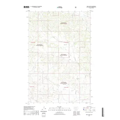
2020 Map of Wolf Coulee
USGS Topo · Published 2020About this map
Little Missouri National Grassland dominates this McKenzie County landscape, where the broken terrain is defined by the namesake Wolf Coulee and the elevated expanse of Maverick Flat. The map reveals a complex network of ephemeral waterways, including Beicegel Cr, Bummer Cr, and Cottonwood Cr, which have carved deep into the Badlands-style topography. This 2020 survey is an essential resource for tracing the long-distance Maah Daah Hey trail as it winds through the federally managed lands, intersecting with remote secondary roads like Canyon Cr Rd and Beicegel Creek Rd. The sparse infrastructure highlights the area's use for grazing and recreation rather than permanent settlement, preserving the character of the North Dakota wilderness.
Find a feature on this map
18 named features on this map. Tap any name to fly to it.
Don’t see what you’re looking for? This feature index may not catch every label — zoom into the map to look around manually.
Map Details
Editions of this 2020 Wolf Coulee Map
This is the sole edition of this map. No revisions or reprints were ever made.
Other maps of this area

1953 · Watford City
USGS Topo · 1:250,000

1957 · Watford City
USGS Topo · 1:250,000

1958 · Long X Divide
USGS Topo · 1:24,000

1958 · Sperati Point
USGS Topo · 1:24,000

1967 · Watford City
USGS Topo · 1:250,000

1970 · Hanks Gully
USGS Topo · 1:24,000

1974 · Wolf Coulee
USGS Topo · 1:24,000

1974 · Squaretop Butte
USGS Topo · 1:24,000

1974 · Buckskin Butte
USGS Topo · 1:24,000
1974 · Scairt Woman Draw
USGS Topo · 1:24,000