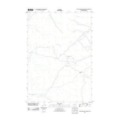
2011 Map of Wolf Mountain Lookout
USGS Topo · Published 2011About this map
Wolf Mountain Lookout Tower stands as the central landmark in this high-country portion of Big Horn County, overseeing a landscape defined by deep drainages and isolated ridges. The topographic layout is shaped by the headwaters of numerous creeks, including the South Fork Reno Creek in the north and Sioux Pass Creek to the south. Navigational routes like Corral Cr Rd and Sioux Pass Creek Rd provide the primary access through this remote terrain, winding between features such as Shortys Hill and the steep walls of Cook Stove Canyon. This 2011 survey illustrates a sparse settlement pattern dominated by natural features like Grey Blanket Creek and Cache Creek, highlighting the region's character as a working landscape of open range and forest management prior to modern developments.
Find a feature on this map
13 named features on this map. Tap any name to fly to it.
Don’t see what you’re looking for? This feature index may not catch every label — zoom into the map to look around manually.
Map Details
Editions of this 2011 Wolf Mountain Lookout Map
This is the sole edition of this map. No revisions or reprints were ever made.
Other maps of this area

1894 · Rosebud
USGS Topo · 1:125,000

1901 · Rosebud
USGS Topo · 1:125,000

1954 · Hardin
USGS Topo · 1:250,000

1957 · Hardin
USGS Topo · 1:250,000

1958 · Hardin
USGS Topo · 1:250,000

1967 · Lodge Grass NE
USGS Topo · 1:24,000

1967 · Kid Creek
USGS Topo · 1:24,000

1967 · Wolf Mountain Lookout
USGS Topo · 1:24,000

1967 · Bar V Ranch NE
USGS Topo · 1:24,000
1967 · Wyola NE
USGS Topo · 1:24,000