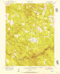
1949 Map of Wolf
USGS Topo · Published 1954About this map
The Camp Beale Military Reservation dominates the western half of this landscape, its boundary cutting through a rugged terrain of prominent peaks including Sugar Loaf Mtn and Rock Mtn. This late-1940s survey captures the region as it transitioned from its mining roots toward ranching and military use. The southern border is defined by the Bear River, where the settlement of Garden Bar and the Cranston Ranch are located. Evidence of the area's hydraulic history remains visible through a complex network of features such as the Ditch, Flume, and Siphon that crisscross the hillsides.
Find a feature on this map
38 named features on this map. Tap any name to fly to it.
Don’t see what you’re looking for? This feature index may not catch every label — zoom into the map to look around manually.
Map Details
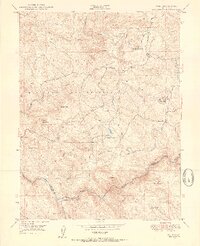
Editions of this 1949 Wolf Map
3 editions found

Other maps of this area

1888 · Smartsville
USGS Topo · 1:125,000

1891 · Sacramento
USGS Topo · 1:125,000

1891 · Smartsville
USGS Topo · 1:125,000

1892 · Sacramento
USGS Topo · 1:125,000

1892 · Smartsville
USGS Topo · 1:125,000

1893 · Sacramento
USGS Topo · 1:125,000

1894 · Smartsville
USGS Topo · 1:125,000

1895 · Smartsville
USGS Topo · 1:125,000
1910 · Lincoln
USGS Topo · 1:31,680
1915 · Spenceville
USGS Topo · 1:31,680