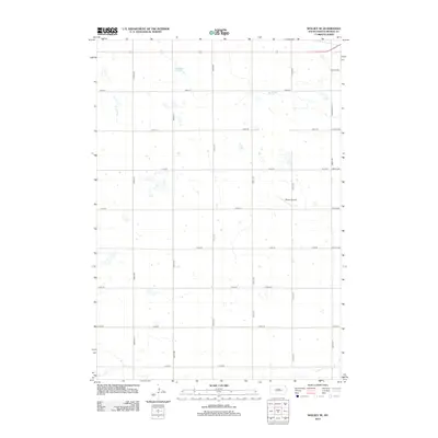
2012 Map of Wolsey SE
USGS Topo · Published 2012About this map
Winter Airfield serves as a primary landmark in this rural section of Beadle County, located south of the main Highway 14 corridor. The landscape is defined by the section-line grid of roads, including 393rd Ave and 210th St, which organize the expansive agricultural fields. Natural drainage patterns are visible through the intermittent waters of Schwartz Slough and the winding course of Stony Run in the northern portion of the quadrangle. In the south, Cain Cr crosses the plains, illustrating the subtle topography of the James River Valley region. The map reflects a modern rural infrastructure where isolated farmsteads and small aviation facilities represent the primary human imprint on the vast South Dakota prairie.
Find a feature on this map
25 named features on this map. Tap any name to fly to it.
Don’t see what you’re looking for? This feature index may not catch every label — zoom into the map to look around manually.
Map Details
Editions of this 2012 Wolsey SE Map
This is the sole edition of this map. No revisions or reprints were ever made.
Other maps of this area

1898 · Huron
USGS Topo · 1:125,000

1953 · Huron
USGS Topo · 1:250,000

1954 · Huron
USGS Topo · 1:250,000

1957 · Huron
USGS Topo · 1:24,000

1958 · Forestburg NW
USGS Topo · 1:24,000

1958 · Huron NW
USGS Topo · 1:24,000
1973 · Wolsey
USGS Topo · 1:24,000

1973 · Alpena
USGS Topo · 1:24,000
1973 · Broadland
USGS Topo · 1:24,000
1973 · Virgil
USGS Topo · 1:24,000