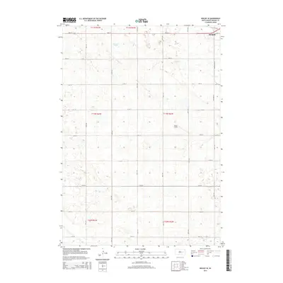
2015 Map of Wolsey SE
USGS Topo · Published 2015About this map
The western outskirts of Huron dominate the northeastern corner of this South Dakota landscape, where the prairie grid system organizes the rural terrain of Beadle County. Transportation and drainage patterns define the local geography, anchored by the route of Old Mn-14 and a series of numbered section roads from 208th St down to 216th St. The area's natural hydrology is marked by the presence of Schwartz Slough and meandering waterways like Stony Run and Cain Cr, which cut through the agricultural sections. A notable landmark for regional aviation and land use is the Winter Airfield, situated centrally among the townships. The map provides a clear view of the Public Land Survey System boundaries, including t110n r62w, showing how the land was partitioned for settlement and farming.
Find a feature on this map
21 named features on this map. Tap any name to fly to it.
Don’t see what you’re looking for? This feature index may not catch every label — zoom into the map to look around manually.
Map Details
Editions of this 2015 Wolsey SE Map
This is the sole edition of this map. No revisions or reprints were ever made.
Other maps of this area

1898 · Huron
USGS Topo · 1:125,000

1953 · Huron
USGS Topo · 1:250,000

1954 · Huron
USGS Topo · 1:250,000

1957 · Huron
USGS Topo · 1:24,000

1958 · Forestburg NW
USGS Topo · 1:24,000

1958 · Huron NW
USGS Topo · 1:24,000
1973 · Wolsey
USGS Topo · 1:24,000

1973 · Alpena
USGS Topo · 1:24,000
1973 · Broadland
USGS Topo · 1:24,000
1973 · Virgil
USGS Topo · 1:24,000