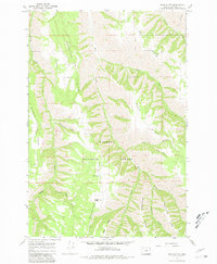
1967 Map of Wood Butte
USGS Topo · Published 1981About this map
Powwatka Ridge and a series of deep drainage basins define this portion of the Wallowa National Forest during the mid-1960s. The landscape is characterized by a radial pattern of ridges, including Kuhn Ridge, Washboard Ridge, and McAlister Ridge, which separate various watercourses like Rattlesnake Creek and Tope Creek.
Find a feature on this map
22 named features on this map. Tap any name to fly to it.
Don’t see what you’re looking for? This feature index may not catch every label — zoom into the map to look around manually.
Map Details
Editions of this 1967 Wood Butte Map
2 editions found
Other maps of this area

1955 · Grangeville
USGS Topo · 1:250,000

1957 · Sled Springs
USGS Topo · 1:62,500

1959 · Grangeville
USGS Topo · 1:250,000

1964 · Akers Butte
USGS Topo · 1:24,000

1967 · Wood Butte
USGS Topo · 1:24,000

1967 · Troy
USGS Topo · 1:24,000

1967 · Eden
USGS Topo · 1:24,000
1967 · Shamrock Creek
USGS Topo · 1:24,000

1967 · Promise
USGS Topo · 1:24,000
1967 · Flora
USGS Topo · 1:24,000