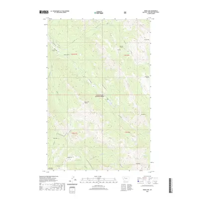
2020 Map of Wood Lake
USGS Topo · Published 2020About this map
Lewis & Clark National Forest encompasses the high-altitude terrain of this quadrangle, where the Lewis and Clark Range creates a formidable vertical landscape. The high-country character is defined by peaks like Fairview Mtn and Crown Mtn, separated by the Elbow Pass and the distinctive Wood Creek Hogback. Remote access to this wilderness area is anchored by the Benchmark Airport near Wood Canyon, while the Continental Divide National Scenic Trail winds through the southern reaches of the map near Bunyan Point. Hydrological patterns are dominated by numerous drainages, including Wood Cr and the waters of Wood Lake. The presence of the Patrol Mtn L O on the western edge of the sheet reflects the ongoing forest management and fire observation infrastructure essential to this heavily timbered region.
Find a feature on this map
44 named features on this map. Tap any name to fly to it.
Don’t see what you’re looking for? This feature index may not catch every label — zoom into the map to look around manually.
Map Details
Editions of this 2020 Wood Lake Map
This is the sole edition of this map. No revisions or reprints were ever made.
Other maps of this area

1903 · Saypo
USGS Topo · 1:125,000

1903 · Coopers Lake
USGS Topo · 1:125,000

1955 · Choteau
USGS Topo · 1:250,000

1957 · Choteau
USGS Topo · 1:250,000

1958 · Choteau
USGS Topo · 1:250,000

1958 · Sawtooth Ridge
USGS Topo · 1:24,000

1958 · Pretty Prairie
USGS Topo · 1:24,000

1958 · Patricks Basin
USGS Topo · 1:24,000

1962 · Choteau
USGS Topo · 1:250,000
1970 · Scapegoat Mountain
USGS Topo · 1:24,000