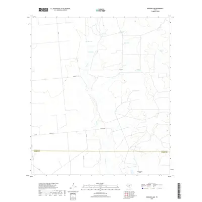
2019 Map of Woodard Lake
USGS Topo · Published 2019About this map
Tortuga Cr meanders across the South Texas brush country, defining the hydrology of a landscape largely organized around ranching and water management. This area on the border of Zavala Co and Dimmit Co is marked by numerous artificial catchments, including Big Tank, Rock Hill Tank, and the eponymous Woodard Lake. The presence of Tortuga Ranch Airport in the south and various ranch roads like Tortuza Rd and Tortuga Rch Rd indicate the modern infrastructure supporting large-scale landholdings. The terrain is relatively uniform, typical of the Rio Grande Plain, with transportation corridors such as FM 582 and FM 65 providing the primary access through this sparsely populated ranching territory.
Find a feature on this map
18 named features on this map. Tap any name to fly to it.
Don’t see what you’re looking for? This feature index may not catch every label — zoom into the map to look around manually.
Map Details
Editions of this 2019 Woodard Lake Map
This is the sole edition of this map. No revisions or reprints were ever made.
Other maps of this area

1939 · Carrizo Springs
USGS Topo · 1:62,500

1939 · Big Wells
USGS Topo · 1:62,500

1939 · La Pryor
USGS Topo · 1:62,500

1953 · Crystal City
USGS Topo · 1:250,000

1955 · Crystal City
USGS Topo · 1:250,000

1957 · Batesville
USGS Topo · 1:62,500

1961 · Crystal City
USGS Topo · 1:250,000

1968 · Crystal City
USGS Topo · 1:250,000
1972 · Big Wells
USGS Topo · 1:24,000
1972 · Batesville SW
USGS Topo · 1:24,000