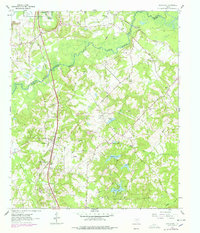
1962 Map of Woodlawn
USGS Topo · Published 1978About this map
Little Cypress Bayou meanders across the border of Marion and Harrison counties, defining a landscape of low-lying wetlands and upland ridges during the early 1960s. The Texas and Pacific railroad serves as the primary corridor for the region, passing through the settlement of Woodlawn and northward toward the bayou. This era in East Texas is characterized by a balance of traditional rural community life and industrial development, evidenced by the numerous country churches like Cypress Chapel and Colliers Chapel alongside active natural gas infrastructure.
Find a feature on this map
25 named features on this map. Tap any name to fly to it.
Don’t see what you’re looking for? This feature index may not catch every label — zoom into the map to look around manually.
Map Details
Editions of this 1962 Woodlawn Map
3 editions found
Other maps of this area

1944 · Kildare
USGS Topo · 1:62,500

1944 · Caddo Lake
USGS Topo · 1:62,500

1946 · Caddo Lake
USGS Topo · 1:62,500

1948 · Kildare
USGS Topo · 1:62,500

1956 · Tyler
USGS Topo · 1:250,000

1962 · Kellyville
USGS Topo · 1:24,000

1962 · Marshall NW
USGS Topo · 1:24,000

1962 · Marshall West
USGS Topo · 1:24,000

1962 · Woodlawn
USGS Topo · 1:24,000
1962 · Smithland
USGS Topo · 1:24,000