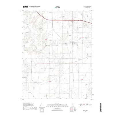
2018 Map of Woodlawn
USGS Topo · Published 2018About this map
Woodlawn stands as the primary hub of this Southern Illinois landscape, where a grid of rural routes and family-named roads connects small settlements and agricultural tracts. The area is defined by its significant concentration of early community landmarks, including nearly a dozen burial sites such as Oddfellows Cem, Reynolds Cem, and Randolph Cem. These sites, alongside the community of Roaches, offer a window into the ancestral footprint of Jefferson County. The terrain transitions from the low-lying wetlands of the Big Muddy River in the northeast to the defined height of The Pinnacle above Rayse Creek. This drainage system, which includes Novak Creek, has historically influenced the placement of farms and cemeteries like Black Cem and Rightnowar Cem, situated on slightly higher ground above the seasonally wet bottoms.
Find a feature on this map
79 named features on this map. Tap any name to fly to it.
Don’t see what you’re looking for? This feature index may not catch every label — zoom into the map to look around manually.
Map Details
Editions of this 2018 Woodlawn Map
This is the sole edition of this map. No revisions or reprints were ever made.
Other maps of this area

1926 · Duquoin
USGS Topo · 1:62,500

1933 · Mount Vernon
USGS Topo · 1:48,000

1939 · Ina
USGS Topo · 1:62,500

1940 · Mount Vernon
USGS Topo · 1:62,500

1943 · Ina
USGS Topo · 1:62,500

1943 · Ashley
USGS Topo · 1:62,500

1946 · Ashley
USGS Topo · 1:62,500

1958 · Belleville
USGS Topo · 1:250,000

1962 · Belleville
USGS Topo · 1:250,000
1965 · Mount Vernon
USGS Topo · 1:24,000