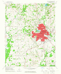
1965 Map of Mount Vernon
USGS Topo · Published 1966About this map
The city of Mount Vernon serves as the focal point of this Jefferson County survey, shown during a period of mid-century expansion. The landscape is defined by a dense network of civic and social infrastructure, including the State Sanatorium, Childrens Home, and the Mt Vernon State Game Farm. The map captures the convergence of significant rail lines, such as the Chicago and Eastern Illinois, which facilitated the region's industrial growth. Outside the city limits, the rural character remains intact with several family and community landmarks like Old Shiloh Cem and Wolf Prairie Cem. Numerous Oil Wells dot the southern fields of Field and McClellan townships, indicating the importance of resource extraction to the local economy. Water features like Peckerwood Lake and the Big Muddy River frame the western boundaries, while numerous rural schools like West Salem Sch anchor the outlying settlements.
Find a feature on this map
64 named features on this map. Tap any name to fly to it.
Don’t see what you’re looking for? This feature index may not catch every label — zoom into the map to look around manually.
Map Details
Editions of this 1965 Mount Vernon Map
2 editions found
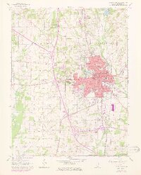
Other maps of this area

1926 · Duquoin
USGS Topo · 1:62,500

1933 · Mount Vernon
USGS Topo · 1:48,000

1939 · Ina
USGS Topo · 1:62,500

1940 · Mount Vernon
USGS Topo · 1:62,500

1943 · Ina
USGS Topo · 1:62,500

1943 · Ashley
USGS Topo · 1:62,500

1946 · Ashley
USGS Topo · 1:62,500

1958 · Belleville
USGS Topo · 1:250,000

1962 · Belleville
USGS Topo · 1:250,000

1964 · Opdyke
USGS Topo · 1:24,000
Featured Places
- Mount Vernon, IL
- Bakerville, IL
- Drivers, IL
- Webster Hill Estates, Mount Vernon
- Morganville, Mount Vernon