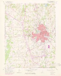
1965 Map of Mount Vernon
USGS Topo · Published 1978About this map
The Mount Vernon regional hub is defined here by its intersection of major transportation and social infrastructure in the mid-1960s. The city serves as a core for Jefferson County, anchored by a central Courthouse and Post Office, while outlying areas like Drivers and Bakerville show the broader rural settlement pattern. Significant institutional presence is marked by the State Sanatorium and a local Childrens Home, alongside the growth of higher education at the Community College. To the south, the Mt Vernon State Game Farm and portions of the Rend Lake State Waterfowl Management Area illustrate the conservation and land management efforts of the era. The landscape is carved by the Big Muddy River and Casey Fork, with water resources secured at the L & N Reservoir and recreational spaces found at the Indian Hills Country Club. Three major railroads—the Southern, Missouri Pacific, and Louisville and Nashville—converge here, reflecting the city's historical role as a rail transit point.
Find a feature on this map
73 named features on this map. Tap any name to fly to it.
Don’t see what you’re looking for? This feature index may not catch every label — zoom into the map to look around manually.
Map Details
Editions of this 1965 Mount Vernon Map
2 editions found
Other maps of this area

1926 · Duquoin
USGS Topo · 1:62,500

1933 · Mount Vernon
USGS Topo · 1:48,000

1939 · Ina
USGS Topo · 1:62,500

1940 · Mount Vernon
USGS Topo · 1:62,500

1943 · Ina
USGS Topo · 1:62,500

1943 · Ashley
USGS Topo · 1:62,500

1946 · Ashley
USGS Topo · 1:62,500

1958 · Belleville
USGS Topo · 1:250,000

1962 · Belleville
USGS Topo · 1:250,000

1964 · Opdyke
USGS Topo · 1:24,000
Featured Places
- Mount Vernon, IL
- Bakerville, IL
- Drivers, IL
- Webster Hill Estates, Mount Vernon
- Morganville, Mount Vernon