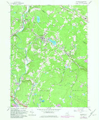
1966 Map of Woodridge
USGS Topo · Published 1982About this map
The Neversink River carves through the western edge of this Catskills-region survey, anchoring a landscape defined by seasonal recreation and institutional land use in the mid-1960s. The village of Woodridge sits at the center, flanked by Silver Lake and the East Pond. To the north, the sprawling grounds of the Woodbourne Correctional Institute occupy a significant bend in the river. This era represents a peak for local tourism and leisure, evidenced by the presence of a Ski Area near Rock Hill, multiple golf courses, a Drive-in Theater, and large bodies of water like Pleasure Lake.
Find a feature on this map
49 named features on this map. Tap any name to fly to it.
Don’t see what you’re looking for? This feature index may not catch every label — zoom into the map to look around manually.
Map Details
Editions of this 1966 Woodridge Map
2 editions found
Other maps of this area

1903 · Slide Mountain
USGS Topo · 1:62,500

1904 · Ellenville
USGS Topo · 1:62,500

1905 · Slide Mountain
USGS Topo · 1:62,500

1906 · Ellenville
USGS Topo · 1:62,500

1909 · Monticello
USGS Topo · 1:62,500

1910 · Neversink
USGS Topo · 1:62,500

1911 · Monticello
USGS Topo · 1:62,500

1942 · Neversink
USGS Topo · 1:62,500

1942 · Lackawack
USGS Topo · 1:24,000
1942 · Ellenville
USGS Topo · 1:24,000