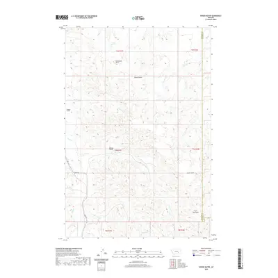
2020 Map of Woods Water
USGS Topo · Published 2020About this map
Haines Reservoir sits in the northern reaches of this High Plains landscape, where the headwaters of numerous seasonal drainages carve deep coulees into the Big Horn Basin. The terrain is defined by a network of intermittent streams like Swede Cr, Nell Cr, and Hay Cr that flow into Sarpy Cr, reflecting the dry-land ranching geography of Rosebud and Treasure Counties. The presence of named landmarks such as Rattlesnake Butte and the namesake Woods Water suggests critical water sources in a region where topography dictates movement. Transportation is largely limited to unpaved routes following the natural contours, most notably Sarpy Rd as it winds through the southern portion of the quadrangle. This map reveals a sparsely settled Montana frontier, where the land is organized by section lines rather than townships, punctuated by deep draws like Whiskey Coulee and Scraper Coulee.
Find a feature on this map
22 named features on this map. Tap any name to fly to it.
Don’t see what you’re looking for? This feature index may not catch every label — zoom into the map to look around manually.
Map Details
Editions of this 2020 Woods Water Map
This is the sole edition of this map. No revisions or reprints were ever made.
Other maps of this area

1954 · Forsyth
USGS Topo · 1:250,000

1957 · Forsyth
USGS Topo · 1:250,000

1958 · Forsyth
USGS Topo · 1:250,000

1960 · Hysham
USGS Topo · 1:24,000

1960 · Sanders
USGS Topo · 1:24,000

1968 · Finch
USGS Topo · 1:24,000

1971 · Griffin Coulee SW
USGS Topo · 1:24,000
1971 · Griffin Coulee NW
USGS Topo · 1:24,000
1972 · Minnehaha Creek North
USGS Topo · 1:24,000
1972 · South Bear Creek
USGS Topo · 1:24,000