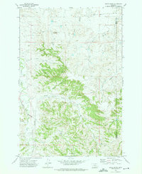
1972 Map of Woods Water
USGS Topo · Published 1975About this map
Rattlesnake Butte dominates the high ground of this Treasure County landscape as it appeared in the early 1970s. The terrain is defined by a dense network of coulees and seasonal drainages, including Whiskey Coulee, Deveny Coulee, and Cache Coulee, which carve through the breaks toward larger watercourses like Sarpy Creek and Hay Creek. Settlement is sparse, represented by the Criswell Ranch and the locality of Woods Water, reflecting the region's ranching character.
Find a feature on this map
20 named features on this map. Tap any name to fly to it.
Don’t see what you’re looking for? This feature index may not catch every label — zoom into the map to look around manually.
Map Details
Editions of this 1972 Woods Water Map
This is the sole edition of this map. No revisions or reprints were ever made.
Other maps of this area

1954 · Forsyth
USGS Topo · 1:250,000

1957 · Forsyth
USGS Topo · 1:250,000

1958 · Forsyth
USGS Topo · 1:250,000

1960 · Hysham
USGS Topo · 1:24,000

1960 · Sanders
USGS Topo · 1:24,000

1968 · Finch
USGS Topo · 1:24,000

1971 · Griffin Coulee SW
USGS Topo · 1:24,000
1971 · Griffin Coulee NW
USGS Topo · 1:24,000
1972 · Minnehaha Creek North
USGS Topo · 1:24,000
1972 · South Bear Creek
USGS Topo · 1:24,000