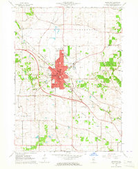
1963 Map of Woodstock
USGS Topo · Published 1964About this map
Woodstock serves as the focal point of this 1960s study, showing a developed municipal core surrounded by the agricultural townships of Hartland, Greenwood, Seneca, and Dorr. The local economy and layout are defined by the Chicago and North Western railway, which bisects the city and connects it to the wider region. Institutional landmarks including the Courthouse, Marian High Sch, and St Marys Sch anchor the downtown grid, while peripheral developments like the Woodstock Country Club and Mass Airport reflect mid-century growth.
Find a feature on this map
74 named features on this map. Tap any name to fly to it.
Don’t see what you’re looking for? This feature index may not catch every label — zoom into the map to look around manually.
Map Details
Editions of this 1963 Woodstock Map
3 editions found
Other maps of this area

1925 · Elgin
USGS Topo · 1:62,500

1926 · Mc Henry
USGS Topo · 1:62,500

1932 · Harvard
USGS Topo · 1:48,000

1937 · Harvard
USGS Topo · 1:62,500

1938 · Genoa
USGS Topo · 1:62,500

1940 · Elgin
USGS Topo · 1:62,500

1944 · McHenry
USGS Topo · 1:62,500

1954 · Rockford
USGS Topo · 1:250,000

1955 · Rockford
USGS Topo · 1:250,000

1958 · Rockford
USGS Topo · 1:250,000