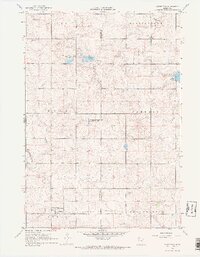
1967 Map of Woodstock
USGS Topo · Published 1968About this map
Woodstock serves as the primary hub in this southwestern Minnesota prairie landscape, situated near the intersection of the Burke and Chanarambie townships. The map documents a transition in local infrastructure, most notably the transition of former rail lines into an Old Railroad Grade that runs south of the town site. The surrounding terrain is defined by the East Branch Rock River and numerous wetland areas dedicated to conservation, including the Woodstock State Wildlife Management Areas and Van Beek State Wildlife Management Area. Genealogists and local historians can pinpoint rural civic life through markers like the Townhall and School No 1264, while the physical geography is punctuated by several Gravel Pits and the prominent elevation of Stony Point in the northwest.
Find a feature on this map
21 named features on this map. Tap any name to fly to it.
Don’t see what you’re looking for? This feature index may not catch every label — zoom into the map to look around manually.
Map Details
Editions of this 1967 Woodstock Map
2 editions found
Other maps of this area

1953 · Watertown
USGS Topo · 1:250,000

1953 · New Ulm
USGS Topo · 1:250,000

1954 · Fairmont
USGS Topo · 1:250,000

1955 · Sioux Falls
USGS Topo · 1:250,000

1957 · New Ulm
USGS Topo · 1:250,000

1958 · New Ulm
USGS Topo · 1:250,000

1958 · Sioux Falls
USGS Topo · 1:250,000

1958 · Fairmont
USGS Topo · 1:250,000

1958 · Watertown
USGS Topo · 1:250,000

1967 · New Ulm
USGS Topo · 1:250,000