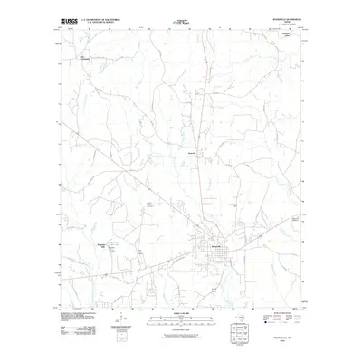
2010 Map of Woodville
USGS Topo · Published 2010About this map
Woodville serves as the focal point of this Southeast Texas landscape, situated at the junction of several regional routes and the Tyler County Airport. The settlement pattern extends north to the Dies Community and Doucette, reflecting a community structure tied to the surrounding piney woods and creek systems. Water is a defining element of the geography, with the Wolf Creek and Turkey Creek drainages feeding several managed water bodies, including those held by the Josiah Wheat Lake Dam and Forest Lake Dam. The development of Magnolia Hills and its associated Magnolia Hills Lake suggests a shift toward residential and recreational use near the town center. Local industry and land use are further evidenced by the Dunrovin Hatchery and the network of named timber and county roads, such as Timber Rd 24 and Cobb Mill Rd, which delineate the working landscape of Tyler County.
Find a feature on this map
54 named features on this map. Tap any name to fly to it.
Don’t see what you’re looking for? This feature index may not catch every label — zoom into the map to look around manually.
Map Details
Editions of this 2010 Woodville Map
This is the sole edition of this map. No revisions or reprints were ever made.
Other maps of this area

1954 · Beaumont
USGS Topo · 1:250,000

1955 · Woodville
USGS Topo · 1:62,500

1955 · Camden
USGS Topo · 1:62,500

1957 · Beaumont
USGS Topo · 1:250,000

1958 · Segno
USGS Topo · 1:62,500

1958 · Warren
USGS Topo · 1:62,500
1984 · Chester
USGS Topo · 1:24,000

1984 · Beaumont
USGS Topo · 1:250,000

1984 · Jacks Creek North
USGS Topo · 1:24,000
1984 · Woodville
USGS Topo · 1:24,000