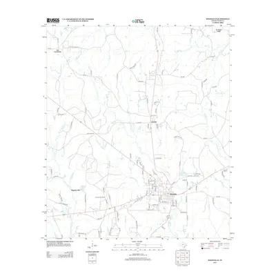
2013 Map of Woodville
USGS Topo · Published 2013About this map
Woodville serves as the focal point of this Tyler County survey, where the convergence of several major routes, including the Old Livingston Hwy, anchors the regional landscape. The town's layout is surrounded by a dense network of watercourses, most notably Turkey Creek and its various branches, which define the local drainage patterns. North of the town center, the small settlements of Doucette and the Dies Community are positioned along the primary north-south corridors, while Magnolia Hills and the adjacent Magnolia Hills Lake sit to the west. This period in the early 21st century shows a balance between established residential clusters and the surrounding piney woods geography, evidenced by features like the Tyler County Airport and recreational spots such as Haralson Lakes. The name Railroad Rd near the southern edge of town hints at the area's historical reliance on timber transport and rail infrastructure.
Find a feature on this map
103 named features on this map. Tap any name to fly to it.
Don’t see what you’re looking for? This feature index may not catch every label — zoom into the map to look around manually.
Map Details
Editions of this 2013 Woodville Map
This is the sole edition of this map. No revisions or reprints were ever made.
Other maps of this area

1954 · Beaumont
USGS Topo · 1:250,000

1955 · Woodville
USGS Topo · 1:62,500

1955 · Camden
USGS Topo · 1:62,500

1957 · Beaumont
USGS Topo · 1:250,000

1958 · Segno
USGS Topo · 1:62,500

1958 · Warren
USGS Topo · 1:62,500
1984 · Chester
USGS Topo · 1:24,000

1984 · Beaumont
USGS Topo · 1:250,000

1984 · Jacks Creek North
USGS Topo · 1:24,000
1984 · Woodville
USGS Topo · 1:24,000