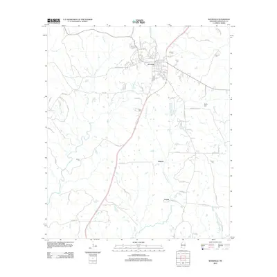
2012 Map of Woodville
USGS Topo · Published 2012About this map
Woodville sits at the northern end of this survey, serving as a hub where local routes like Pinckneyville Rd and Natchez St converge. The landscape to the south is defined by the winding paths of Bayou Sara and the W Fork Thompson Cr, reflecting a rural Wilkinson County character shaped by watercourses and small settlements. The distribution of family-named burial grounds across the area, including Sweeney Cem and Liddell Cem, offers a detailed spatial record for genealogists. Smaller communities such as Ashwood and Turnbull are positioned along the primary north-south corridor, illustrating the established settlement pattern of the early twenty-first century. This topography shows a network of named lanes and roads, from Lovers Ln to Wyoming Rd, that connect isolated residences and farms to the larger community centers.
Find a feature on this map
81 named features on this map. Tap any name to fly to it.
Don’t see what you’re looking for? This feature index may not catch every label — zoom into the map to look around manually.
Map Details
Editions of this 2012 Woodville Map
This is the sole edition of this map. No revisions or reprints were ever made.
Other maps of this area

1906 · Bayou Sara
USGS Topo · 1:125,000

1936 · Woodville
USGS Topo · 1:62,500

1939 · St. Francisville
USGS Topo · 1:62,500

1941 · Lost Creek
USGS Topo · 1:31,680

1945 · Lost Creek
USGS Topo · 1:31,680

1953 · Natchez
USGS Topo · 1:250,000

1954 · Baton Rouge
USGS Topo · 1:250,000

1956 · Natchez
USGS Topo · 1:250,000

1956 · Baton Rouge
USGS Topo · 1:250,000
1958 · Clinton
USGS Topo · 1:62,500