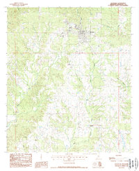
1988 Map of Woodville
USGS Topo · Published 1988About this map
Woodville serves as the central hub of this 1980s southwestern Mississippi landscape, situated amidst a dense network of creek drainages and timbered terrain. The map documents a transition in local transportation, most notably showing an Old RR Grade south of the main settlement, indicating a shift from rail dependence to road networks near the Louisiana border. Small rural communities like Ashwood and Turnbull are positioned along the southern corridors, while a remote Landing Strip suggests the importance of aerial access for local agriculture or industry.
Find a feature on this map
18 named features on this map. Tap any name to fly to it.
Don’t see what you’re looking for? This feature index may not catch every label — zoom into the map to look around manually.
Map Details
Editions of this 1988 Woodville Map
This is the sole edition of this map. No revisions or reprints were ever made.
Other maps of this area

1906 · Bayou Sara
USGS Topo · 1:125,000

1936 · Woodville
USGS Topo · 1:62,500

1939 · St. Francisville
USGS Topo · 1:62,500

1941 · Lost Creek
USGS Topo · 1:31,680

1945 · Lost Creek
USGS Topo · 1:31,680

1953 · Natchez
USGS Topo · 1:250,000

1954 · Baton Rouge
USGS Topo · 1:250,000

1956 · Natchez
USGS Topo · 1:250,000

1956 · Baton Rouge
USGS Topo · 1:250,000
1958 · Clinton
USGS Topo · 1:62,500