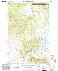
1999 Map of Woodworth
USGS Topo · Published 2003About this map
Blackfoot River flows through the southern reach of this landscape, marking a terrain defined by the transition from the Lolo National Forest down into the broad Blanchard Flats. The map records a mixture of public conservation land and early ranching history, notably centered around the Blackfoot Clearwater Wildlife Management Area. Small settlements and landmarks such as Woodworth, Bandy, and Cozy Corners dot the area, while the presence of the Park Sch and Old Boyd Ranch points to the localized rural infrastructure of the late 20th century. Transportation is anchored by Clearwater Junction at the southwestern corner, connecting the river valley to the north through routes like the Tote Road. This 1999 revision reveals a landscape where wildlife management and fishing access, such as the Russell Gates Fishing Access, have become primary features of the river corridor.
Find a feature on this map
25 named features on this map. Tap any name to fly to it.
Don’t see what you’re looking for? This feature index may not catch every label — zoom into the map to look around manually.
Map Details
Editions of this 1999 Woodworth Map
This is the sole edition of this map. No revisions or reprints were ever made.
Other maps of this area

1902 · Ovando
USGS Topo · 1:125,000

1905 · Ovando
USGS Topo · 1:125,000

1919 · Drummond
USGS Topo · 1:125,000

1921 · Drummond
USGS Topo · 1:125,000

1947 · Butte
USGS Topo · 1:250,000

1955 · Choteau
USGS Topo · 1:250,000

1957 · Choteau
USGS Topo · 1:250,000

1958 · Butte
USGS Topo · 1:250,000

1958 · Choteau
USGS Topo · 1:250,000

1960 · Butte
USGS Topo · 1:250,000