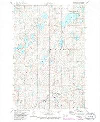
1972 Map of Woodworth
USGS Topo · Published 1986About this map
Woodworth serves as the focal point of this prairie landscape in the early 1970s, situated along the Burlington Northern railroad line. The settlement is surrounded by an intricate glacial wetland system, characterized by numerous small potholes and larger water bodies like Barnes Lake, Colby Lake, and Meander Lake. Much of this terrain is designated as a National Waterfowl Production Area, reflecting the region's importance for migratory birds. To the south, the Gem Cem and a prominent Radio Tower provide specific landmarks for genealogists and local historians. The map also delineates several civil boundaries, including Wadsworth, Gerber, and Strong, while the southern expanse is dominated by the terrain of Marston Moor. Evidence of local industry is seen in the small Gravel Pit located north of the town site.
Find a feature on this map
16 named features on this map. Tap any name to fly to it.
Don’t see what you’re looking for? This feature index may not catch every label — zoom into the map to look around manually.
Map Details
Editions of this 1972 Woodworth Map
2 editions found
Other maps of this area

1948 · Carrington
USGS Topo · 1:62,500

1950 · Carrington SW
USGS Topo · 1:24,000

1952 · New Rockford
USGS Topo · 1:250,000

1956 · New Rockford
USGS Topo · 1:250,000
1958 · Goldwin SW
USGS Topo · 1:24,000

1958 · Goldwin
USGS Topo · 1:24,000

1971 · New Rockford
USGS Topo · 1:250,000

1972 · Woodworth
USGS Topo · 1:24,000
1972 · Lake Louise
USGS Topo · 1:24,000
1972 · Pearl Lake
USGS Topo · 1:24,000