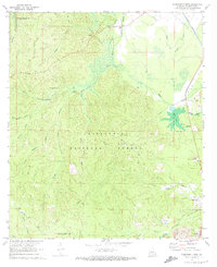
1971 Map of Woodworth West
USGS Topo · Published 1973About this map
Woodworth and its surrounding piney woods were documented in the early 1970s as a landscape defined by timber, water management, and military proximity. The vast acreage of the Kisatchie National Forest covers the majority of the terrain, punctuated by features like Castor Plunge and the Magnolia Recreation Area. Along the southern border, the legacy of World War II remains visible in the U S Air Force Gunnery Range (Camp Claiborne). Water is central to this geography, from the Kincaid Reservoir at the northwest corner to the intricate network of Boeuf Bayou and the man-made Diversion Channel. The map captures local infrastructure including the Woodworth Landing Strip, numerous Gravel Pits, and an old RR Grade, while cemeteries such as Alexandria Memorial Gardens and Sunrise Memorial Gardens provide critical points of interest for genealogists.
Find a feature on this map
45 named features on this map. Tap any name to fly to it.
Don’t see what you’re looking for? This feature index may not catch every label — zoom into the map to look around manually.
Map Details
Editions of this 1971 Woodworth West Map
2 editions found
Other maps of this area

1932 · Boyce SW
USGS Topo · 1:31,680

1935 · Lecompte
USGS Topo · 1:62,500

1941 · Alexandria
USGS Topo · 1:62,500

1941 · Boyce
USGS Topo · 1:62,500

1945 · Boyce SE
USGS Topo · 1:31,680

1949 · Boyce SE
USGS Topo · 1:31,680

1953 · Alexandria
USGS Topo · 1:250,000

1955 · Alexandria
USGS Topo · 1:250,000

1956 · Forest Hill
USGS Topo · 1:62,500

1956 · Boyce
USGS Topo · 1:62,500