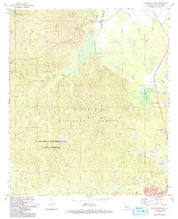
1971 Map of Woodworth West
USGS Topo · Published 1993About this map
Kisatchie National Forest dominates this section of Rapides Parish, characterized by the dense dendritic drainage patterns of Loving Creek, Castor Branch, and Brushy Creek. The landscape is defined by its transition from the wooded uplands to the alluvial lowlands of the Bayou Boeuf basin. In the heart of the forest, the US Air Force Gunnery Range (Camp Claiborne) marks a significant military footprint, while the Alexander State Forest provides a managed buffer to the south.
Find a feature on this map
43 named features on this map. Tap any name to fly to it.
Don’t see what you’re looking for? This feature index may not catch every label — zoom into the map to look around manually.
Map Details
Editions of this 1971 Woodworth West Map
2 editions found
Other maps of this area

1932 · Boyce SW
USGS Topo · 1:31,680

1935 · Lecompte
USGS Topo · 1:62,500

1941 · Alexandria
USGS Topo · 1:62,500

1941 · Boyce
USGS Topo · 1:62,500

1945 · Boyce SE
USGS Topo · 1:31,680

1949 · Boyce SE
USGS Topo · 1:31,680

1953 · Alexandria
USGS Topo · 1:250,000

1955 · Alexandria
USGS Topo · 1:250,000

1956 · Forest Hill
USGS Topo · 1:62,500

1956 · Boyce
USGS Topo · 1:62,500