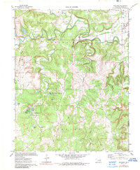
1971 Map of Woolaroc
USGS Topo · Published 1989About this map
Woolaroc Museum and its surrounding preserve anchor this Osage County landscape, characterized by a complex network of springs and small lakes. In the early 1970s, the area remained a blend of conservation and active resource extraction, with numerous oil wells, gas wells, and a dedicated pipeline corridor cutting through the terrain. Named water sources such as Nehawaski Spring, Ponce De Leon Spring, and Spencer Spring suggest a landscape where water access was historically critical. The Missouri-Kansas-Texas railroad line follows the path of Sand Creek, passing near the small settlement of Torpedo. Cultural markers like the Mausoleum and the Wah-Shah-She Girl Scout Camp provide evidence of the diverse land use within the Indian Reservation boundary.
Find a feature on this map
39 named features on this map. Tap any name to fly to it.
Don’t see what you’re looking for? This feature index may not catch every label — zoom into the map to look around manually.
Map Details
Editions of this 1971 Woolaroc Map
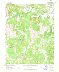
2 editions found
Other maps of this area

1901 · Nowata
USGS Topo · 1:125,000

1906 · Nelagoney
USGS Topo · 1:24,000

1909 · Pawhuska
USGS Topo · 1:125,000

1910 · Pawhuska
USGS Topo · 1:125,000

1914 · Nowata
USGS Topo · 1:125,000

1954 · Tulsa
USGS Topo · 1:250,000

1955 · Enid
USGS Topo · 1:250,000

1958 · Enid
USGS Topo · 1:250,000

1958 · Tulsa
USGS Topo · 1:250,000

1960 · Nelagoney
USGS Topo · 1:24,000