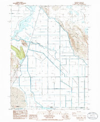
1986 Map of Worden
USGS Topo · Published 1986About this map
Lower Klamath Lake and the surrounding basin define this landscape on the border of Oregon and California, where a massive network of levees and canals dominates the terrain. This mid-1980s data shows the highly managed hydrology of the region, featuring infrastructure like USBR Pumping Plant F and a unique Siphon under Road & R.R. designed to move water beneath the transportation corridor. The Southern Pacific railroad and the Pacific Highway run parallel along the western edge of the basin, passing through the small settlement of Midland and near the Worden Cem.
Find a feature on this map
29 named features on this map. Tap any name to fly to it.
Don’t see what you’re looking for? This feature index may not catch every label — zoom into the map to look around manually.
Map Details
Editions of this 1986 Worden Map
This is the sole edition of this map. No revisions or reprints were ever made.
Other maps of this area

1886 · Modoc Lava Bed
USGS Topo · 1:250,000

1889 · Klamath
USGS Topo · 1:250,000

1892 · Modoc Lava-Bed
USGS Topo · 1:250,000

1894 · Klamath
USGS Topo · 1:250,000

1950 · Mt. Dome
USGS Topo · 1:62,500

1950 · Dorris
USGS Topo · 1:62,500

1954 · Alturas
USGS Topo · 1:250,000

1955 · Klamath Falls
USGS Topo · 1:250,000

1957 · Merrill
USGS Topo · 1:62,500

1957 · Klamath Falls
USGS Topo · 1:62,500