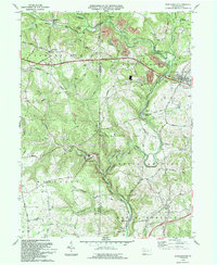
1993 Map of Worthington
USGS Topo · Published 1993About this map
Worthington and the surrounding borderlands of Butler and Armstrong counties are defined by the winding course of Buffalo Creek, which carves through the undulating terrain of West Franklin and Winfield townships. This 1993 edition, based on earlier surveys and updated via 1990s aerial photography, documents a landscape where agricultural settlements like Slate Lick and industrial outposts like West Winfield coexist. The infrastructure of the era is clearly visible, from the Buffalo and Pittsburgh Railroad crossing the creek to the Benjamin Franklin Highway cutting through the northern reaches. Local history is anchored by rural landmarks such as St Johns Ch, McKee Chapel, and the milling sites of Buffalo Mills and Dennys Mills. The map also captures the extent of natural resource extraction, showing various Strip Mine and Quarry operations alongside conservation efforts at State Game Lands No 259.
Find a feature on this map
41 named features on this map. Tap any name to fly to it.
Don’t see what you’re looking for? This feature index may not catch every label — zoom into the map to look around manually.
Map Details
Editions of this 1993 Worthington Map
This is the sole edition of this map. No revisions or reprints were ever made.
Other maps of this area

1900 · Kittanning
USGS Topo · 1:62,500

1902 · Kittanning
USGS Topo · 1:62,500

1907 · Freeport
USGS Topo · 1:62,500

1908 · New Kensington
USGS Topo · 1:62,500

1909 · Freeport
USGS Topo · 1:62,500

1909 · Butler
USGS Topo · 1:62,500

1910 · New Kensington
USGS Topo · 1:62,500

1911 · Butler
USGS Topo · 1:62,500

1953 · Pittsburgh
USGS Topo · 1:250,000
1953 · Curtisville
USGS Topo · 1:24,000