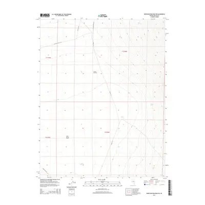
2014 Map of Worthington Peak SW
USGS Topo · Published 2014About this map
Sand Spring Valley occupies the heart of this high-desert landscape in Lincoln County, where the topography transitions from the low flat of Hecker Dry Lake toward the rising slopes of the Worthington range. This 2014 survey documents a network of remote access roads that define human movement across the arid basin, including Mcclutchen Rd and Wild Horse Spring Rd. For local history researchers, these routes trace the essential connections between reliable water sources like Rose Spring, Shadow Spring, and Stinking Spring. The presence of the Apple Reservoir in the southern portion of the valley suggests the continued importance of water management in an environment where natural springs dictate the geography of land use and livestock movement.
Find a feature on this map
15 named features on this map. Tap any name to fly to it.
Don’t see what you’re looking for? This feature index may not catch every label — zoom into the map to look around manually.
Map Details
Editions of this 2014 Worthington Peak SW Map
This is the sole edition of this map. No revisions or reprints were ever made.
Other maps of this area

1942 · Penoyer Valley
USGS Topo · 1:125,000

1952 · White Blotch Springs
USGS Topo · 1:62,500

1954 · Caliente
USGS Topo · 1:250,000

1959 · Caliente
USGS Topo · 1:250,000

1964 · Tempiute Mtn
USGS Topo · 1:62,500

1985 · Worthington Peak
USGS Topo · 1:24,000

1985 · McCutchen Spring
USGS Topo · 1:24,000
1985 · Quinn Canyon Springs
USGS Topo · 1:24,000

1985 · Worthington Peak SW
USGS Topo · 1:24,000
1985 · Meeker Peak
USGS Topo · 1:24,000