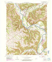
1952 Map of Worthville
USGS Topo · Published 1988About this map
The Kentucky River winds sharply through a landscape of deep valleys and winding ridges where Carroll, Henry, and Owen Counties meet. At the northern bend, Worthville serves as a small rail and river hub, situated where Eagle Creek and Mill Creek join the main channel. The presence of the CSX railroad corridor along the riverbank highlights the area's historical role as a transport artery for northern Kentucky.
Find a feature on this map
29 named features on this map. Tap any name to fly to it.
Don’t see what you’re looking for? This feature index may not catch every label — zoom into the map to look around manually.
Map Details
Editions of this 1952 Worthville Map
3 editions found
Other maps of this area

1906 · Lockport
USGS Topo · 1:48,000

1908 · Lockport
USGS Topo · 1:62,500

1928 · New Castle
USGS Topo · 1:48,000

1932 · New Castle
USGS Topo · 1:62,500

1943 · Brooksburg
USGS Topo · 1:24,000

1943 · Vevay South
USGS Topo · 1:24,000

1950 · New Liberty
USGS Topo · 1:24,000

1951 · Sanders
USGS Topo · 1:24,000

1952 · Vevay South
USGS Topo · 1:24,000

1952 · Worthville
USGS Topo · 1:24,000