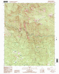
1992 Map of Wren Peak
USGS Topo · Published 1995About this map
The Kings River serves as the powerful central artery for this portion of the Sierra Nevada, carved through by the Middle Fork Kings River and the South Fork Kings River. The landscape is dominated by the intersecting boundaries of the Sierra National Forest, the Sequoia National Forest, and the Monarch Wilderness. This survey captures the region's botanical and geological significance, identifying numerous giant sequoia groves such as the Windy Gulch Grove, Evans Grove, and Kennedy Grove. Human presence is marked by ephemeral locations like the Camp Seven (Site) and the notable Boyden Cave near the Windy Cliffs. The intricate drainage network of Redwood Creek and Evans Creek illustrates the complex watershed that feeds the high-altitude meadows, including Tornado Meadow and Deer Meadow.
Find a feature on this map
59 named features on this map. Tap any name to fly to it.
Don’t see what you’re looking for? This feature index may not catch every label — zoom into the map to look around manually.
Map Details
Editions of this 1992 Wren Peak Map
2 editions found
Other maps of this area

1903 · Tehipite
USGS Topo · 1:125,000

1905 · Tehipite
USGS Topo · 1:125,000

1948 · Fresno
USGS Topo · 1:250,000

1952 · Tehipite Dome
USGS Topo · 1:62,500

1953 · Marion Peak
USGS Topo · 1:62,500

1955 · Fresno
USGS Topo · 1:250,000

1956 · Fresno
USGS Topo · 1:250,000

1956 · Giant Forest
USGS Topo · 1:62,500
1956 · Triple Divide Peak
USGS Topo · 1:62,500

1958 · Fresno
USGS Topo · 1:250,000