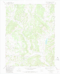
1983 Map of Wrights Reservoir
USGS Topo · Published 1983About this map
Pike National Forest covers the northern reaches of this Colorado landscape, where the boundary between Park and Teller counties divides a high-altitude terrain of named peaks and winding drainage systems. Slater Creek and Fourmile Creek dictate the local geography, converging toward the central landmark of Wrights Reservoir. This early 1980s survey captures a rural network of small-scale industry and community life, evidenced by a scattering of Quarry sites and a Gravel Pit alongside local landmarks like Beasley Hills and Dog Head. The map serves as a vital record for genealogists and local historians, documenting the exact location of the Fourmile Ch and Fourmile Cem, which along with the settlement of Pinewood, represent the social anchors of this mountainous region before modern development patterns fully took hold.
Find a feature on this map
29 named features on this map. Tap any name to fly to it.
Don’t see what you’re looking for? This feature index may not catch every label — zoom into the map to look around manually.
Map Details
Editions of this 1983 Wrights Reservoir Map
2 editions found
Other maps of this area

1894 · Pikes Peak
USGS Topo · 1:125,000

1901 · Pikes Peak
USGS Topo · 1:125,000

1901 · Pikes Peak
USGS Topo · 1:62,500

1942 · Cover Mtn.
USGS Topo · 1:62,500

1948 · Cover Mtn.
USGS Topo · 1:62,500

1951 · Cripple Creek South
USGS Topo · 1:24,000

1951 · Cripple Creek North
USGS Topo · 1:24,000

1954 · Divide
USGS Topo · 1:24,000

1954 · Pueblo
USGS Topo · 1:250,000

1956 · Lake George
USGS Topo · 1:24,000