
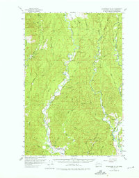
1955 Map of Wynoochee Valley
USGS Topo · Published 1964About this map
The Wynoochee River carves a winding path through the heart of the Olympic Peninsula foothills in this mid-century survey of Grays Harbor County. The landscape is defined by the timber industry and river systems, with a complex network of waterways including the West Fork Satsop River and the East Fork Wishkah River. Local community life is anchored at the Wynoochee Grange and the small settlement of Simpson, while the southern reaches show the early development of Sylvia Lake State Park around Sylvia Lake. A distinctive Logging Railroad snakes through the northeast, illustrating the era's reliance on rail for moving timber from the drainages of Canyon Creek and Caldwell Creek. High-ground markers like Money Lookout and Prices Peak offer vantage points over the heavy forest canopy, while small markers like a lonely Cem near the Satsop suggest the long-standing family roots in these river valleys.
Find a feature on this map
53 named features on this map. Tap any name to fly to it.
Don’t see what you’re looking for? This feature index may not catch every label — zoom into the map to look around manually.
Map Details
Editions of this 1955 Wynoochee Valley Map
3 editions found

Other maps of this area

1921 · Quinault Lake
USGS Topo · 1:62,500

1921 · Satsop
USGS Topo · 1:62,500

1940 · Montesano
USGS Topo · 1:62,500

1941 · Mobray
USGS Topo · 1:62,500

1941 · Ford
USGS Topo · 1:62,500

1943 · Humptulips
USGS Topo · 1:62,500

1943 · Nahwatzel Lake
USGS Topo · 1:62,500

1943 · Mobray
USGS Topo · 1:62,500

1953 · Hoquiam
USGS Topo · 1:250,000

1953 · Mt Tebo
USGS Topo · 1:62,500