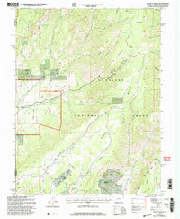
2001 Map of X Lazy F Ranch
USGS Topo · Published 2004About this map
Gunnison Mesa and Soap Mesa dominate this high-altitude landscape within the Gunnison National Forest. The map, updated at the start of the 21st century from earlier surveys, documents a region defined by ranching activity and rugged drainage systems. The presence of the Childress Cow Camp and Winter Cabin suggests a history of seasonal high-country use, likely for cattle grazing. Water resources are critical in this terrain, as evidenced by Victory Lake, Blue Lake, and the man-made Allen Pond. The drainage network is complex, featuring Crystal Creek and Curecanti Creek carving through deep gulches like Hartman Gulch and Commissary Gulch. The Hartman Trail and numerous unpaved 4WD tracks provide the primary means of navigating the plateaus, including the prominent Black Mesa which straddles the Montrose and Gunnison county line.
Find a feature on this map
32 named features on this map. Tap any name to fly to it.
Don’t see what you’re looking for? This feature index may not catch every label — zoom into the map to look around manually.
Map Details
Editions of this 2001 X Lazy F Ranch Map
This is the sole edition of this map. No revisions or reprints were ever made.
Other maps of this area

1908 · Uncompahgre
USGS Topo · 1:125,000

1909 · Montrose
USGS Topo · 1:125,000

1911 · Uncompahgre
USGS Topo · 1:125,000

1911 · Montrose
USGS Topo · 1:125,000

1954 · Little Soap Park
USGS Topo · 1:24,000

1954 · Sapinero
USGS Topo · 1:24,000

1956 · Curecanti Needle
USGS Topo · 1:24,000

1956 · Cimarron
USGS Topo · 1:24,000

1956 · Montrose
USGS Topo · 1:250,000

1957 · Cathedral Peak
USGS Topo · 1:24,000