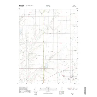
2018 Map of Xenia
USGS Topo · Published 2018About this map
Skillet Fork and its many meandering tributaries, including Grabapple Br and Conners Br, dominate this central Illinois landscape at the border of Marion and Clay Counties. The settlement of Xenia sits near the southeastern corner, serving as a focal point for the surrounding rural area. Genealogists will find a high concentration of small burial grounds scattered across the townships, such as the Edwards Family Cem, Shadden Cem, and Stipp Cem. The presence of the Independent Order of Oddfellows Cem in Xenia reflects the civic and fraternal history of the community. To the northwest, the waters of Forbes Lake provide a significant geographical landmark, while the small community of Greendale and nearby Greendale Lake anchor the southern portion of the survey. The map reveals a highly structured grid of county roads, such as Co Hwy 18 and Co Rd 18, which connect these dispersed rural features.
Find a feature on this map
88 named features on this map. Tap any name to fly to it.
Don’t see what you’re looking for? This feature index may not catch every label — zoom into the map to look around manually.
Map Details
Editions of this 2018 Xenia Map
This is the sole edition of this map. No revisions or reprints were ever made.
Other maps of this area

1934 · Salem
USGS Topo · 1:62,500

1938 · Salem
USGS Topo · 1:62,500

1945 · Kinmundy
USGS Topo · 1:62,500

1947 · Kinmundy
USGS Topo · 1:62,500

1952 · Xenia
USGS Topo · 1:62,500

1956 · Edgewood
USGS Topo · 1:62,500

1958 · Belleville
USGS Topo · 1:250,000

1962 · Belleville
USGS Topo · 1:250,000

1965 · Iuka
USGS Topo · 1:24,000
1965 · Omega
USGS Topo · 1:24,000