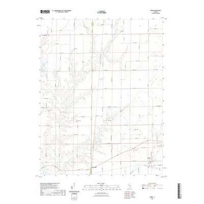
2021 Map of Xenia
USGS Topo · Published 2021About this map
Xenia and the surrounding Xenia Township landscape are defined by a network of creeks and family-named landmarks in the early 21st century. The village serves as a southern hub, while the terrain to the north is carved by the Skillet Fork and its numerous tributaries, including Crabapple Br, Pickle Cr, and Conners Br. For genealogists and local historians, this survey is exceptionally dense with burial sites, documenting family and community grounds such as Oddfellows Cem, Onstott Cem, and the Edwards Family Cem. The boundary between Marion and Clay counties bisects the western half of the map, passing through the small settlement of Greendale. Beyond the township centers, the area consists primarily of rural road networks and natural features like Forbes Lake and Jamison Cr, illustrating the persistent agricultural and riparian character of this southern Illinois region.
Find a feature on this map
86 named features on this map. Tap any name to fly to it.
Don’t see what you’re looking for? This feature index may not catch every label — zoom into the map to look around manually.
Map Details
Editions of this 2021 Xenia Map
This is the sole edition of this map. No revisions or reprints were ever made.
Other maps of this area

1934 · Salem
USGS Topo · 1:62,500

1938 · Salem
USGS Topo · 1:62,500

1945 · Kinmundy
USGS Topo · 1:62,500

1947 · Kinmundy
USGS Topo · 1:62,500

1952 · Xenia
USGS Topo · 1:62,500

1956 · Edgewood
USGS Topo · 1:62,500

1958 · Belleville
USGS Topo · 1:250,000

1962 · Belleville
USGS Topo · 1:250,000

1965 · Iuka
USGS Topo · 1:24,000
1965 · Omega
USGS Topo · 1:24,000