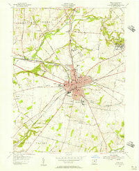
1955 Map of Xenia
USGS Topo · Published 1956About this map
Xenia serves as a major hub for Southwest Ohio in the mid-1950s, where the intersection of the Pennsylvania Railroad and the Baltimore and Ohio Railroad creates a dense industrial and residential core. The city is flanked by significant institutions, including the sprawling Soldiers and Sailors Orphans Home and numerous local schools like Spring Hill Sch and Lincoln Sch. To the northeast, the academic corridor of Wilberforce is clearly defined by the campuses of Wilberforce University and Central State College.
Find a feature on this map
75 named features on this map. Tap any name to fly to it.
Don’t see what you’re looking for? This feature index may not catch every label — zoom into the map to look around manually.
Map Details
Editions of this 1955 Xenia Map
This is the sole edition of this map. No revisions or reprints were ever made.
Other maps of this area

1904 · Springfield
USGS Topo · 1:62,500

1904 · Dayton
USGS Topo · 1:62,500

1906 · Dayton
USGS Topo · 1:62,500

1906 · Springfield
USGS Topo · 1:62,500

1913 · Waynesville
USGS Topo · 1:62,500

1915 · Waynesville
USGS Topo · 1:62,500

1917 · Xenia
USGS Topo · 1:62,500

1947 · Columbus
USGS Topo · 1:250,000

1953 · Cincinnati
USGS Topo · 1:250,000

1954 · Clifton
USGS Topo · 1:24,000
Featured Places
- Xenia, OH
- Xenia Township, OH
- Sugarcreek Township, OH
- Beavercreek Township, OH
- Spring Valley Township, OH