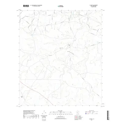
2019 Map of Y O Ranch
USGS Topo · Published 2019About this map
The Y O Ranch Airport and West Kerr Ranch Airport serve as central hubs in this ranching landscape of Kerr County, Texas. This 2019 survey documents a terrain defined by extensive private road networks and water management features like Bundy Tank, essential for sustaining livestock and wildlife in the Hill Country. A distinct hunting and recreational character is evident through features such as Deer Park and Gobblers Knob, while the local topography is etched by drainage ways like Deadman Gulch and the Johnson Fork. The naming conventions of roads, including Indian Mound Rd NW and Comanche Trails Rd, reference the region's cultural history. Long-distance transit is represented by Camino Real Rd and the path of Route 83, illustrating the intersection of modern infrastructure with historic travel corridors.
Find a feature on this map
38 named features on this map. Tap any name to fly to it.
Don’t see what you’re looking for? This feature index may not catch every label — zoom into the map to look around manually.
Map Details
Editions of this 2019 Y O Ranch Map
This is the sole edition of this map. No revisions or reprints were ever made.
Other maps of this area

1932 · Junction
USGS Topo · 1:62,500

1954 · Llano
USGS Topo · 1:250,000

1955 · Llano
USGS Topo · 1:250,000

1956 · Llano
USGS Topo · 1:250,000

1963 · Garven Store
USGS Topo · 1:24,000

1963 · Y O Ranch
USGS Topo · 1:24,000

1964 · Boneyard Draw
USGS Topo · 1:24,000

1964 · Live Oak Ranch
USGS Topo · 1:24,000
1971 · Earwood Creek
USGS Topo · 1:24,000
1971 · Horse Camp Waterhole
USGS Topo · 1:24,000