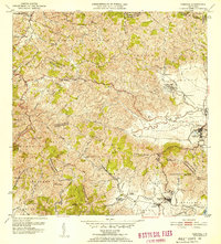
1952 Map of Yabucoa
USGS Topo · Published 1953About this map
The agricultural Valle de Yabucoa dominates this 1952 landscape, where the sugar industry is evidenced by the presence of Central Roig and associated settlements like Colonia Laura and Batey Columbia. The survey captures the coastal southeastern corner of Puerto Rico before significant modern development, showing the transition from the high peaks of the Sierra de Panduras down to the Mar Caribe at Punta Tuna. Local education centers, including the Escuela C S Ridley and Escuela Segunda Unidad Palo Seco, serve as vital landmarks for genealogists tracing mid-century community life. The settlement patterns of Yabucoa and Maunabo are clearly delineated alongside the numerous watercourses, such as the Rio Guayanes and Rio Maunabo, which define the region's fertile topography.
Find a feature on this map
70 named features on this map. Tap any name to fly to it.
Don’t see what you’re looking for? This feature index may not catch every label — zoom into the map to look around manually.
Map Details
Editions of this 1952 Yabucoa Map
2 editions found
Other maps of this area

1945 · Punta Tuna
USGS Topo · 1:30,000

1946 · Patillas
USGS Topo · 1:30,000

1946 · Humacao
USGS Topo · 1:30,000

1946 · Punta Guayanes
USGS Topo · 1:30,000

1946 · Juncos
USGS Topo · 1:30,000

1946 · Yabucoa
USGS Topo · 1:30,000

1946 · Guayama
USGS Topo · 1:30,000

1946 · Caguas
USGS Topo · 1:30,000
1947 · Humacao SO
USGS Topo · 1:10,000

1947 · Yabucoa SO
USGS Topo · 1:10,000