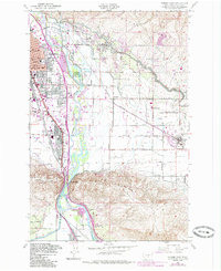
1953 Map of Yakima East
USGS Topo · Published 1985About this map
The Yakima River bisects this mid-century landscape, carving a gap between the Ahtanum Ridge and the Rattlesnake Hills. The city of Yakima dominates the northwestern corner, showing its established urban grid with landmarks like the State Fairgrounds and several neighborhood schools including Madison Sch and Adams Sch. Eastward, the Moxee Valley reveals a robust agricultural irrigation system featuring the Roza Canal and Selah Moxee Canal, which sustain the smaller settlements of Moxee City and Birchfield. The map illustrates a transitional era where traditional rail infrastructure like the Burlington Northern railroad meets modern mid-century additions such as the KIMA Radio TV Center and a Drive-in Theater. Genealogists may find value in the locations of the Pioneer Cem near the river or the Holland Cem located further east in the valley.
Find a feature on this map
51 named features on this map. Tap any name to fly to it.
Don’t see what you’re looking for? This feature index may not catch every label — zoom into the map to look around manually.
Map Details
Editions of this 1953 Yakima East Map
3 editions found
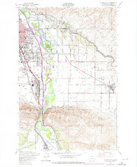
Other maps of this area

1899 · Ellensburg
USGS Topo · 1:125,000

1901 · Ellensburg
USGS Topo · 1:125,000

1910 · Zillah
USGS Topo · 1:125,000

1936 · Yakima East
USGS Topo · 1:48,000

1937 · White Swan
USGS Topo · 1:125,000

1941 · Yakima East
USGS Topo · 1:62,500

1950 · Yakima
USGS Topo · 1:250,000

1953 · Pomona
USGS Topo · 1:24,000

1953 · Elephant Mountain
USGS Topo · 1:24,000

1953 · Yakima East
USGS Topo · 1:24,000