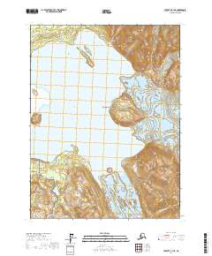
2017 Map of Yakutat A-1 NE
USGS Topo · Published 2017About this map
Glacier Bay National Park and the adjacent Glacier Bay National Preserve dominate this 2017 study of the Alaskan coast. The map centers on the dynamic environment of Alsek Lake, where the massive face of the Alsek Glacier meets the water. This glacial system creates a distinctive landscape of ice-carved terrain and shifting hydrology, including the flow of the Doame River and its connection to Lower Doame Lake to the south. The prominent Gateway Knob stands as a notable landmark on the western shore, overlooking the lake and the glacial terminus. The mapping of these federal lands, coordinated with agencies like the BLM and FWS, captures the coastal topography of the Yakutat City and Borough area, reflecting the natural progression of one of the world's most active glacial corridors.
Find a feature on this map
11 named features on this map. Tap any name to fly to it.
Don’t see what you’re looking for? This feature index may not catch every label — zoom into the map to look around manually.
Map Details
Editions of this 2017 Yakutat A-1 NE Map
This is the sole edition of this map. No revisions or reprints were ever made.
Other maps of this area

1951 · Yakutat
USGS Topo · 1:250,000

1952 · Skagway
USGS Topo · 1:250,000

1959 · Yakutat A-1
USGS Topo · 1:63,360

1959 · Yakutat B-1
USGS Topo · 1:63,360

1959 · Yakutat
USGS Topo · 1:250,000
1961 · Skagway B-8
USGS Topo · 1:63,360

1961 · Skagway A-8
USGS Topo · 1:63,360

1961 · Skagway
USGS Topo · 1:250,000

1997 · Yakutat B-1
USGS Topo · 1:63,360
2017 · Yakutat A-1 NW
USGS Topo · 1:25,000