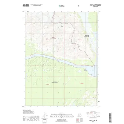
2017 Map of Yakutat A-1 NW
USGS Topo · Published 2017About this map
The Brabazon Range dominates the northern landscape of this coastal Alaskan region, where the towering peaks of the Tongass National Forest meet the protected wilderness of Glacier Bay National Park. The hydrology of the area is defined by the powerful Alsek River, which flows westward toward the Gulf of Alaska, fed by the expansive Alsek Lake in the eastern portion of the map. South of the river, the land transitions into the Glacier Bay National Preserve, a vast expanse of wetlands and braids including the Doame River and Cabin Slough. Human presence is minimal and restricted to primitive routes such as the Alsek N Trail and the Tractor N Trail which parallel the riverbanks. This 2017 survey illustrates a dynamic glacial landscape where river systems and mountain ranges define the boundaries of three major federal land designations.
Find a feature on this map
14 named features on this map. Tap any name to fly to it.
Don’t see what you’re looking for? This feature index may not catch every label — zoom into the map to look around manually.
Map Details
Editions of this 2017 Yakutat A-1 NW Map
This is the sole edition of this map. No revisions or reprints were ever made.
Other maps of this area

1951 · Yakutat
USGS Topo · 1:250,000

1959 · Yakutat A-1
USGS Topo · 1:63,360

1959 · Yakutat A-2
USGS Topo · 1:63,360

1959 · Yakutat B-2
USGS Topo · 1:63,360

1959 · Yakutat B-1
USGS Topo · 1:63,360

1959 · Yakutat
USGS Topo · 1:250,000

1997 · Yakutat B-1
USGS Topo · 1:63,360
2017 · Yakutat A-1 SW
USGS Topo · 1:25,000
2017 · Yakutat A-2 NE
USGS Topo · 1:25,000
2017 · Yakutat A-1 NE
USGS Topo · 1:25,000